 |
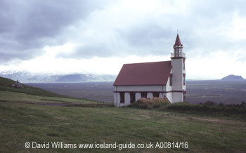
| This is the small church at Hlíðarendi. The large gravel plain behind it carries the Markarfljót. |
 |
| This is the small house I photographed. Although the clouds were incredibly black, no rain fell in the Thórsmörk valley because of its sheltered position. |
The appointed
time soon came. By now I had carried out most of my journey, having crossed
the interior desert twice, forded about a hundred or so rivers and negotiated
tortuous rough tracks over bare lava. But now I was to visit the campsite
at Thórsmörk. And ford the Krossá.
I had never visited Thórsmörk before and it sounded intriguing. It was a small wooded area near Iceland`s south coast and it was sheltered on three sides by three towering ice-caps. These protected Thórsmörk as nearly all the precipitation fell on them, so although there might be cloud and rain on the ice-caps the lower ground was spared the bad weather. No wonder it was popular with Icelanders.
I stayed
at the campsite at Hvolsvöllur, some 20km from where I was to meet
the bus driver at 3pm the next day. The next morning I thoroughly checked
the vehicle, carefully stowing away anything that might work loose during
the river crossings. I pondered over my preparations; the vehicle had
managed the other rivers well and the 2.6 litre engine gave plenty of
reserve power should I need it. However, it was a petrol engine which
was more susceptible to stalling than a diesel should water splash all
over the engine. I sprayed some more water dispersant over the electrics,
just in case. I wondered whether I should remove the fan belt as the rotating
fan might spray water over the engine. I decided against that; the rivers
wouldn`t be that deep - would they ?
I headed eastwards along the ring road to the Markarfljót, the
huge river that flowed out of the Thórsmörk area. The river
had brought down millions of tonnes of black gravel and this had been
a major natural obstacle for the road engineers, especially since the
river keeps changing its course. Huge gravel embankments had been bulldozed
into place to try to keep the river under some semblance of control. Once
over the bridge I turned left onto road 249, which was signed to Thórsmörk.
A notice warned of the dangers that lay ahead. I wandered about, looking
at the starkly beautiful landscape that lay ahead. I was going to follow
the Markarfljót upstream, crossing about twenty of its unbridged
tributaries, four of them dangerous. The Krossá was the last of
the rivers I had to cross and the campsite was situated on its far bank.
I was nervous.
I had arrived with a couple of hours to spare, so I decided to reconnoitre
and drive along the first few kilometres of the route. The gravel track
to Thórsmörk ran beneath the tall cliffs on my right. They
were made of brown palagonite, a rock formed during subglacial volcanic
eruptions. It is much more easily eroded than the surrounding basalt rocks
so over the ages the glaciers and rivers had sliced their way through
the mountains, forming the broad valley which was now dominated by the
Markarfljót. The valley was ringed by the three ice-caps of Eyjafjallajökull,
Mýrdalsjökull and Tindfjallajökull and it was their cold
meltwater which fed the wild glacial rivers which I was now having to
tackle. While the scenery on this side of the Markarfljót was wild
and untamed, the green hillsides on the opposite side of the valley were
long-established farming areas. Indeed, the farm of Hlíðarendi
had been the home of Gunnar Hámundarson, one of the main characters
in Njáls saga, one of Iceland`s best-loved sagas and a great literary
masterpiece which told of murderous feuds many centuries ago.
The track
was quiet and only the occasional 4x4 vehicle passed in either direction.
I took my time, admiring the scenery and trying to psyche myself up for
the task ahead. I crossed eight rivers, none of them giving me any difficulties.
At each river I practiced what Úlfar had taught me: study the river
to watch for turbulent water as this indicates where the submerged boulders
are; cross the river in an S-shaped path and keep heading downstream diagonally,
thereby reducing the surface area of the vehicle being hit by the flow
of water behind me; aim for a point upstream of my proposed landing place
as the river will inevitably push me downstream; keep in low gear, keep
the engine revs high and slip the clutch. And don`t stall the engine,
otherwise the water will rush up the exhaust pipe. Just keep going.
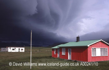
I returned to the beginning of the track, getting more nervous by the minute. I busied myself by taking photographs of a brightly-coloured house clad in corrugated iron. Its red walls and green roof were picked out by a shaft of brilliant sunlight while the sky behind it was jet black.
| Next Page |
| First page of this article |